- Anthropogenic CO<sub>2</sub> emissions assessment of Nile Delta using XCO<sub>2</sub> and SIF data from OCO-2 satellite. Environmental Research Letters, 2020 mehr… Volltext ( DOI )
VALIDATION AND APPLICATION OF SATELLITE MEASUREMENTS OCO-2 (XCO2 and SIF)
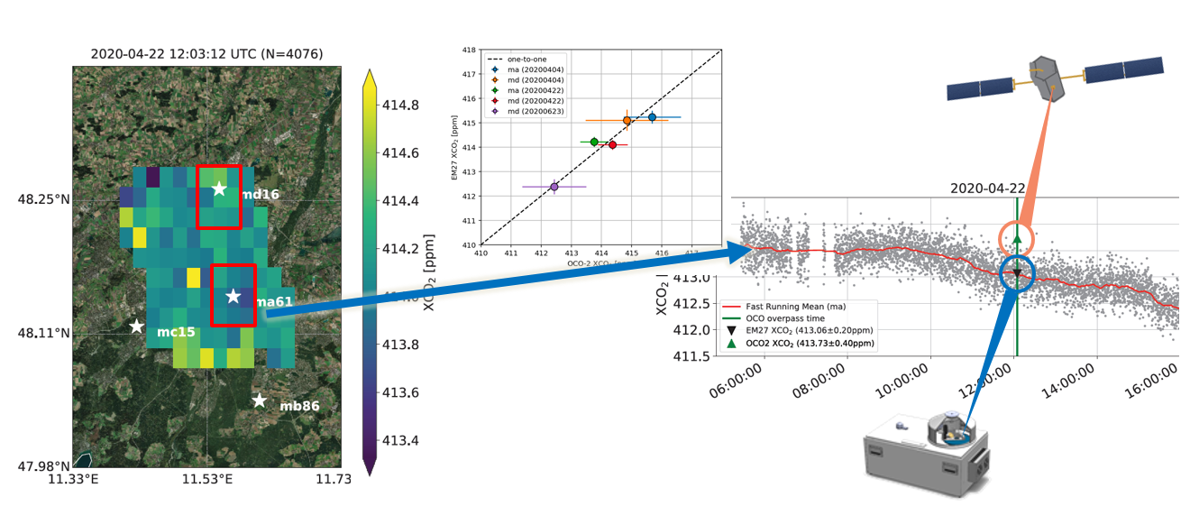
We are validating and examining the urban-rural gradients of CO2 measured by the OCO-2 satellite, in collaboration with NASA JPL. Another approach for differential column measurements is the analysis of column averaged carbon dioxide XCO2 and Solar Induced Fluorescence (SIF) measurements from the Orbiting Carbon Observatory-2 Satellite (OCO-2). Compared to stationary spectrometers, satellite borne measurements provide a global and continuous coverage of XCO2 in our planet’s atmosphere. In the last year we have reliably detected urban areas of different sizes, geographical locations and structure as local carbon sources. Furthermore, the group has shifted its focus on the combined information of SIF and XCO2 concentration measurements. With this combination we hope to be able to precisely identify and characterize anthropogenic and biospheric sources and sinks of carbon dioxide. Urban to rural ΔXCO2 and ΔSIF help us understand the role of gross primary production of terrestrial vegetation within urban carbon cycles.
NASA project: Validation and Application of OCO-2 data in the Northeastern United States
Assessment of the Impact of Drought and Heatwave on Vegetation
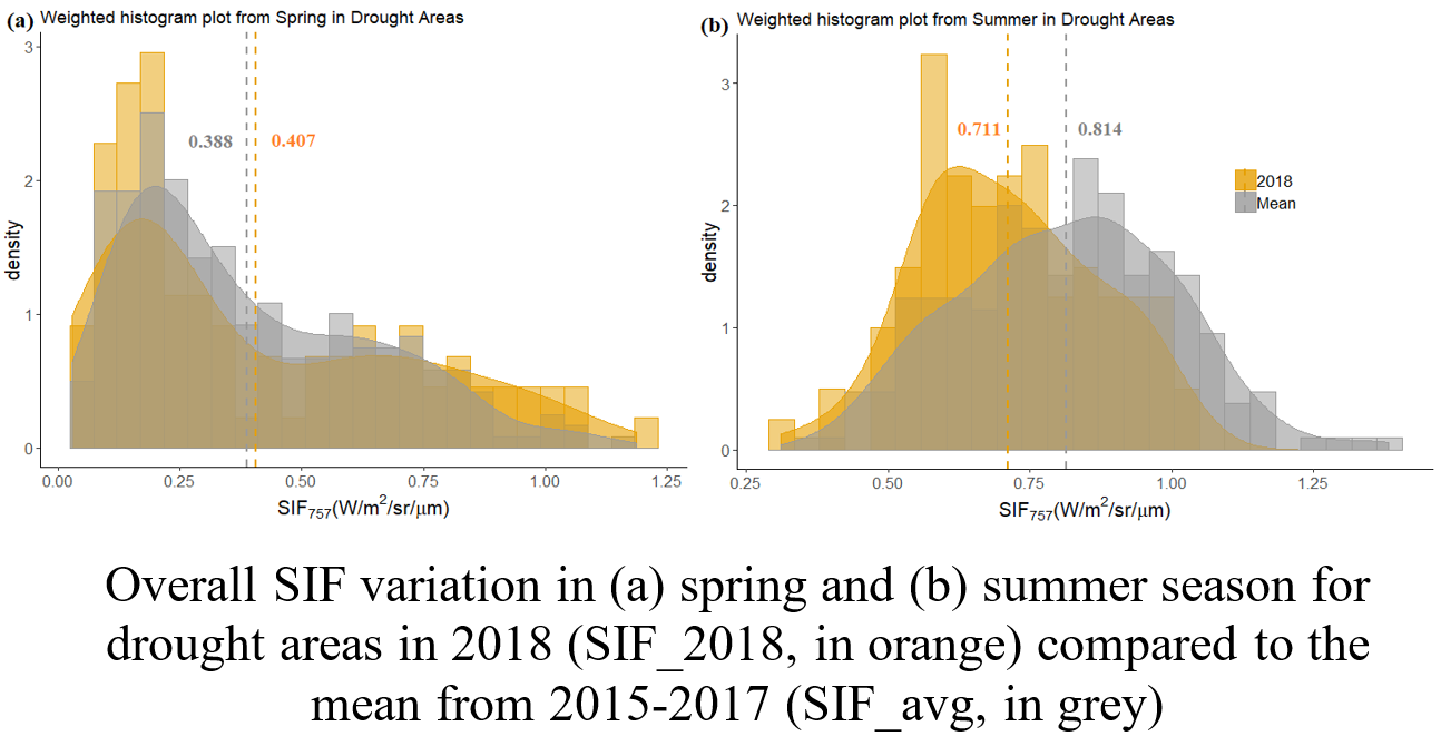
The European heatwave of 2018 exhibited record-breaking temperatures and extreme dry conditions across the whole continent. Our study considers novel and very recent solar-induced fluorescence (SIF) data acquired from the Orbiting Carbon Observatory (OCO-2) satellite. We explore SIF variation during spring and summer months across different vegetation types (agriculture, broad-leaf forest, coniferous forest, and mixed forest) during the European heat and drought in 2018 and compare it to non-drought conditions.
SIF is proposed to be a direct proxy for gross primary productivity (GPP) and thus can be used to draw inferences about changes in photosynthetic activity in vegetation due to extreme events. About one-third of Europe experienced a consecutive spring and summer drought and about one-sixth a severe spring and summer drought in 2018. A definite pattern change in SIF variation is observed within the spring season for all vegetation types, with lower SIF during the start of spring followed by increased in fluorescence from mid-April, even though the SIF difference from the mean was not significant. Summer, however, showed a significant decrease in SIF with the values constantly lower than the mean value. Our results show that particularly agricultural areas were severely affected by the drought and heat of 2018. Further, the variation in the spring-summer SIF was captured across different Köppen climate zones in Europe. The intense heat wave in Central Europe showed about 31 % decrease in SIF value during July and August as compared to the mean over three years.
- Capturing the Impact of the 2018 European Drought and Heat across Different Vegetation Types Using OCO-2 Solar-Induced Fluorescence. Remote Sensing 12 (19), 2020, 3249 mehr… Volltext ( DOI )
- OCO-2 Solar-Induced Chlorophyll Fluorescence Variability across Ecoregions of the Amazon Basin and the Extreme Drought Effects of El Niño (2015–2016). Remote Sensing 12 (7), 2020, 1202 mehr… Volltext ( DOI )
Global Mapping of OCO-2 Measurements
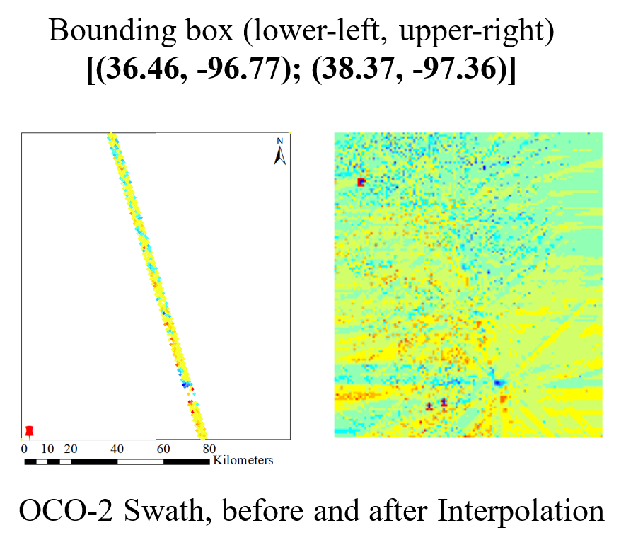
NASA’s Orbiting Carbon Observatory (OCO-2) satellite measurement is one of the most used datasets in the literature of greenhouse gases (GHG). This satellite measures the total column averaged CO2 concentration (also referred to as XCO2) as contiguous parallelogram footprints, roughly one kilometer in diameter. One of the major hindrance associated with this dataset is the missing XCO2 footprints in one particular time instance which eventually propagates in its time-series measurements.
There are few other global datasets related to GHG measurements which mainly provide high-resolution anthropogenic CO2 emission information worldwide, such as ODIAC, EDGAR, FFDAS. This information is highly related to the atmospheric CO2 concentration variation and if modeled as the auxiliary information for the prediction of missing CO2 concentration footprints, may enhance the accuracy in prediction. In this work, we are aiming to combine these emission inventory information along with OCO-2’s XCO2 data for its interpolation process. A Semantic Kriging based interpolation method is considered to carry out the prediction. This method is capable to incorporate related auxiliary information (both numerical and semantic) of the terrain into the prediction process for the enhancement of the prediction accuracy. A motivating example scenario and corresponding source code can be found here.
- Prediction of Satellite-Based Column CO₂ Concentration by Combining Emission Inventory and LULC Information. IEEE Transactions on Geoscience and Remote Sensing, 2020, 1-16 mehr… Volltext ( DOI ) Volltext (mediaTUM)
- Semantic Kriging for Spatio-temporal Prediction. Springer, 2019 mehr… Volltext ( DOI ) Volltext (mediaTUM)